 The Mount Pleasant Community (Block Plan 51-1 in the Mount Pleasant Secondary Plan) represents one of the most unique development projects in the City of Brampton. The future residential community involves the protection, creation and enhancement of over 100 ha (250 ac.) of Natural Heritage System lands. The community will feature neighbourhood centres - prominent nodes with mixed-uses and higher density residential that will strengthen the urban structure and define the character of the surrounding low density neighbourhoods. A Spine Road will link the community from north to south and, most importantly, to the
Mount Pleasant Village ‘Mobility Hub’ and GO Station.
The Mount Pleasant Community (Block Plan 51-1 in the Mount Pleasant Secondary Plan) represents one of the most unique development projects in the City of Brampton. The future residential community involves the protection, creation and enhancement of over 100 ha (250 ac.) of Natural Heritage System lands. The community will feature neighbourhood centres - prominent nodes with mixed-uses and higher density residential that will strengthen the urban structure and define the character of the surrounding low density neighbourhoods. A Spine Road will link the community from north to south and, most importantly, to the
Mount Pleasant Village ‘Mobility Hub’ and GO Station.
Community Vision
The vision for Mount Pleasant is to create a community that is well connected through its road and pathway networks, and to support compact development and healthy active lifestyles. Land uses, community design, housing form and density, open space and natural heritage systems, and recreational amenities such as trails are all intended to support the use of local and regional transit as connected through the Mount Pleasant Village Mobility Hub, GO Station and Brampton's Zum Rapid Transit system that will run along Bovaird Drive to Mississauga Road.
Multiple principles and objectives for the design of this community were established at the outset through the Secondary Plan, and included:
- Protection and enhancement of the Natural Heritage System;
- Transit-oriented design (TOD);
- Defined neighbourhoods with identifiable cores that include retail uses, live/work townhouses located in the Mixed-Use Nodes along the Spine Roads;
- Pedestrian-scaled neighbourhoods;
- A variety of housing and building typologies;
- A hierarchy of open space – the modified park hierarchy that provides a variety of play for all Neighbourhood Parks;
- The incorporation of trails through the NHS and a complementary on-street network (bike lanes and multi-use paths);
- Creation of a road network that balances the demands of the auto and bus with the needs of the pedestrian and cyclist.
The Natural Heritage System – The Focal Point of the Community
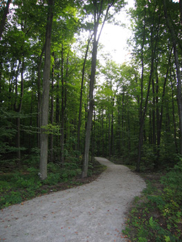
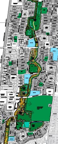 The Mount Pleasant Community is being developed to respect the existing woodlands and wetlands that have been conserved in the historical agricultural landscape. Through development and stewardship, the Mount Pleasant Community will restore and enhance these individual features, that currently cover approximately 8% (or 41 hectares) of the area, and create a Natural Heritage System that will cover approximately 19% (or 97.6 hectares) of the community. East Huttonville Creek will be realigned and re-vegetated within a defined and enhanced floodplain corridor that will connect the fragmented woodlands and wetlands to provide ecologically diverse and sustainable fish and wildlife habitat. The Community’s Natural Heritage System and adjacent open space system is also intended to connect people via a pathway system to schools, parks, commercial areas and residential neighbourhoods. The pathway system includes the Green Trail along East Huttonville Creek corridor, the TCPL Trail that connects Mount Pleasant to Fletcher’s Meadow (east of Creditview Road) and future Heritage Heights (west of Mississauga Road), and on-street bike paths along the Spine Road.
As development proceeds within the Mount Pleasant Community, the NHS will come into public ownership. The City’s Community Services department will be responsible to manage the NHS, and our goal is to support natural processes and regeneration that are beneficial to the health and diversity of the natural features, functions and habitat. This will generally mean:
- Planting no-maintenance vegetative buffers between natural areas and private properties, using native trees, shrubs and groundcovers;
- Not mowing, pruning or spraying natural areas for weeds and insects;
- Allowing for annual flooding and ponding of water along East Huttonville Creek, and within wetlands and woodlands to maintain a natural hydrology that is critical for plant and wildlife health and diversity;
- Allowing for the natural loss of vegetation and regrowth of young trees and shrubs;
- Managing natural areas for invasive species such as Buckthorn and Norway Maple;
- Managing the urban trees along streets and parks for invasive species such as Emerald Ash Borer.
Homeowner’s Guide - "Protecting and Living with our Shared Natural Environment"
The NHS through Mount Pleasant has been a fundamental structuring element in the design of this community. Its long-term protection will depend on careful management of the features that make up the NHS. Residents and users of the NHS will play a prominent role in helping to protect this area.
The City has worked in collaboration with the area’s developers and Credit Valley Conservation (CVC) in the creation of a
Homeowner’s Guide. The guide provides information on how the NHS will function, how it will be maintained and what residents can do to protect this natural asset.
